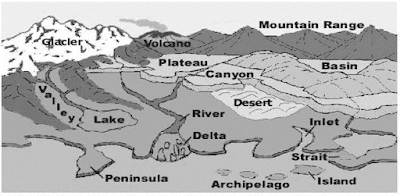
In the very beginning of earth’s history this planet was a giant, red hot, gaseous ball. Gradually this gaseous sphere began to cool and solidified forming a thin crust on its surface. The earth consists of three main layers-the core. the mantle and the crust. The core is the inner part of the earth, the crust is the outer part and between them is the mantle. The crust of the earth is composed of a great variety of rocks. Enduring processes of the landforms of the earth are influenced by form of rocks and minerals. The surface of the earth is always changeable. This changing nature has two faces. One occurs suddenly and the other is a slow process. In this article we shall discuss about internal and external structure of the earth, types of rocks, slow and abrupt change of the earth surface and different types of landforms.
At the end of this article you will be able to :
• Describe the internal structure of the earth.
• Describe the external structure of the earth.
• Describe the landform change of the earth surface.
• Explain the reason of the abrupt change of the earth surface.
• Analyze the result and reason of earthquake, tsunami and
volcano.
• Explain the result and reason of slow change of the earth
surface.
• Explain the rivers path way.
• Discuss the landforms created by rivers.
• Describe the characteristics of the main landforms of the
earth.
• Analyze the impact of tsunami occurred in the past on the
basis of data.
Internal Structure of the Earth
In the very beginning earth was a hot, gaseous ball. From that
condition it became cool and solidified. During that period the heavy metals
concentrated at the centre and comparatively lighter materials sequentially
concentrated around that heavy core according to its density and weight. These
different layers called Spheres. The upper most sphere is called Lithosphere.
The upper part of lithosphere is known as Earth Crust.
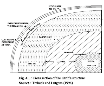
The earth's crust : The
hard stratum of the rock covering the outer shell of the whole earth is known
as the earth's crust (fig. 4.1). The thickness of the earth's crust is the
lowest in comparison to the other interior layers of the earth. On an average,
it is about 20 kilometres. The thickness below the earth's crust on an average
is about 35 kilometres known as SIAL which is composed of Silicon (Si) and of
Aluminium (AL). On the other hand, the earth's crust beneath the ocean is
composed of basalt which is heavier than that of Sial layer and its major
elements are Silicon (Si) and Magnesium (Mg) and is generally known as SIMA.
The external structures such as Mountains, Plateau, and Plains are visible. The
temperature beneath the earth's crust is increased by 30° Celsius for each
kilometre towards its centre.
Barysphere : The stratum beneath the
earth's crust which is about 2,885 kilometres thick is called the Barysphere.
Barysphere mainly consists of Basalt rock. This sphere has silica, magnesium,
iron, carbon, and other minerals. Barysphere is divided into two parts.
(a) Upper Barysphere which is extended up to 700 kilometres.
This stratum mainly composed with silicate minerals enriched with iron and
magnesium.
(b) Lower Barysphere mainly consists of minerals of iron oxide,
magnesium oxide and silicon dioxide.
Centrosphere : Centrosphere
is situated just after the Barysphere. It is extended from the lower parts of the Barysphere up to the
centre of the earth. The thickness of this layer is about 3,486 kilometres. It is
known from the seismic waves that the Centrosphere has a liquid cover which is
about 2,270 kilometres thick and also has a hard inner-part which is about
1,216 kilometres thick. The scientists believe that iron, nickel, mercury and
lead exist among the elements of Centrosphere. But the two major elements of Centrosphere
are iron (Fe) and Nickel (Ni).
Rocks and Minerals
Earth's crust is formed with rocks. Rocks are composed of
different types of minerals. Mineral is the compound form of some basic
elements mixed by natural process. Minerals are natural inorganic elements
which have distinct chemical composition, physical and chemical
characteristics. Though generally minerals are formed by two or more elements
but some minerals can be formed with only one basic element. Such as, diamond,
gold, copper, silver, mercury and sulphur. Rock forming minerals have different
characteristics and most of the rocks are composed with two or more minerals.
In that sense minerals and rocks are the same things. For example, limestone
which is a sedimentary rock also known as calcite is a mineral.
Difference between rocks and minerals : Minerals
are homogenous inorganic matter and the rocks are heterogeneous materials.
Minerals are solids and crystallized, though some rocks are solid but are not
crystallized. Minerals have specific chemical composition but rocks have no
such thing. The characteristics of minerals are determined by the nature of
their constructing elements. Whereas, the nature of rocks are regulated by the
nature of the minerals that compose them.
Classification of Rocks
The materials of the earth crust or lithosphere are generally
called Rock. Every solid and fluid material which formed the earth surface is
rock. Such as pebbles, sandstone, granite, clay, chalks etc. According to
formation of rocks can be classified into three major parts: (1) Igneous rocks,
(2) Sedimentary rocks, (3) Metamorphic rocks.
(1) Igneous rocks : At
the beginning the Earth was a hot gaseous spheroid. This gaseous spheroid was
transformed into liquid by radiating heat. heat. After radiating more heat its
upper part became cool and solidified. Rocks which became solidified from
liquefied state are called Igneous Rocks. As the igneous rocks form at the very
beginning of earth's origin it is also called the Primary Rocks. There are no
layers in this rock type. So, it is also called Unstratified Rock. There is no
fossil in this rock type. The characteristics of igneous rocks are : (a)
granular or crystalline rocks, (b) do not have strata, ( c) hard and less
fragile, ( d) do not contain fossils, ( e) comparatively heavy.
Often volcanism and earthquake create fracture at the weak part
of the earth surface. Then the hot molten lava comes out from the interior of
the earth and forms igneous rocks. In this way Basalt and Granite are created.
Igneous rocks can be divided into two parts : (a) Extrusive igneous rocks, (b)
Intrusive igneous rocks.
(a) Extrusive igneous rocks : The
hot liquid material in the interior of the earth which is called Magma finds
its way to the surface of the earth through the crack of the earth's outer
skin. It is called Lava. The lava after cooling becomes extrusive Igneous
rocks. The granules of the igneous rocks are refined and have deep colour. The
examples of extrusive igneous rocks are Basalt, Rhyolite, Andesite etc.
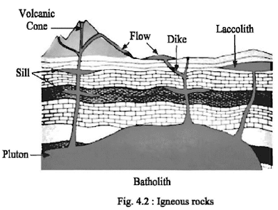
(b) Intrusive igneous rocks: When
the rising magmas during a volcanic activity do not reach the earth's surface rather they
are cooled and solidified below the surface of the earth, the resultant igneous
rocks are called Intrusive Igneous Rocks. The granules of these rocks are coarse
and have light colour. Granite, gabbro, dolerite, laccolith, batholith, dike and sill
are the examples of intrusive igneous rocks (fig. 4.2).
(2) Sedimentary rocks : Sedimentary rocks are formed
due to aggregation and composition of sediments. Due to influence of rain,
wind, glacier, heat, wave etc. igneous rocks are eroded
and disintegrated and transformed into gravel, mud, sand and dust. These eroded rock debris are
transported by stream, wind and glacier and deposited in lowlands, lakes,
ponds, basins, rivers and seas. So, sediments and debris are regularly
deposited by layers. Continuous sedimentation increases the weight and pressure
and different layers are consolidated and compacted to form sedimentary rock.
Sedimentary rocks cover 5 percent area
of total earth's crust. However, 75 percent of the continental
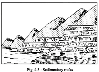
land mass is sedimentary rock. This is called Sedimentary Rocks as this form from
sediments or debris (fig. 4.3).
Sedimentary rocks are also
called as Stratified or Layered Rocks because these rocks have different
layers or strata of different types of sediments. Sedimentary
rock can be formed by mechanical,
organic or chemical processes. Sandstone, coal, shale, limestone, claystone, kaolin
are the examples of sedimentary rocks. As coal and mineral oil originated from organic body these are also called Organic
Rocks. In many sedimentary rocks different types of fossils of plants and
animals are found
Characteristics of sedimentary rocks :
Sedimentary rocks are stratified, soft and light, easy to erode. Fossils can be
seen in sedimentary rocks. This rock is porous.
(3) Metamorphic rocks : Metamorphic rocks form
deep in the earth where high temperature, great pressure, and chemical
reactions cause one type of rock to change into another type of rock. The rocks
are partially melted and the chemicals within them are rearranged so that the
final rock is very different from the original rock. One very common
metamorphic rock is marble. Marble is formed when heat and pressure are applied
to limestone for many thousands of years. Some other examples of metamorphic
rocks are gneiss, slate, schist, and quartzite.
Characteristics of metamorphic rocks :
(a) Classified by texture and composition.
(b) Rarely have fossils.
(c) May have alternate bands of light and dark minerals.
(d) May be composed of only one mineral, example marble and
quartzite.
(e) May have layers of visible crystals.
(f) Usually made of mineral crystals of
different sizes.
(g) Rarely have pores or openings.
(h) May have bent or curved foliation.
Changing Process of the Earth Surface
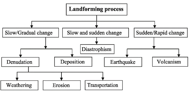
The earth's crust is always changing. Different landforming process
bring about this change. Landforming processes are the activities through which
the changes are caused naturally in the formation of the land. For example, a
river is building a flood plain through deposition. Therefore, the depositional
activities of a river is a landforming process. The landforming processes are
done with the help of different natural forces such as the gravitational
forces, interior temperature, and the solar bring changes on the earth's crust
either slowly or rapidly. Generally, energy. The different landforming
processes with the help of the aforesaid agents external force like solar
energy brings about a slow change in the formation of land. The changes brought
about on earth's surface through longer period of time, is known as slow changes.
The slow changes are caused in two processes, i.e; denudation and deposition.
Gradual change : This
is the opposite of rapid change where changes occur due to natural forces like
solar energy, wind, rain, stream, glacier etc. Generally slow process occur
over a huge area.
Rapid change : The
inner part of the earth is still hot and molten. When there is a difference in
temperature and pressure within this portion there causes earthquakes. Due to
the earthquakes most of the changes occur. Rapid change of the earth surface
mainly occurs due to Earthquakes, Volcanoes, and Tsunami.
Earthquake
An earthquake is a shaking of the ground caused by the sudden
breaking and shifting of rocks beneath the earth surface. The shaking could
last seconds or minutes, and there may be several earthquakes over a period of
time.
Causes of Earthquakes
The scientist have determined various reasons of earthquake by
examining different types of geological events. The causes of earthquakes may
be divided into three main groups (i) surface causes, (ii) volcanic causes and
(iii) tectonic causes.
(i) Surface causes : Great
explosions, landslides, slips on steep coasts, dashing of sea waves,
avalanches, railway trains, heavy trucks, some large engineering projects cause
minor tremors. Some of them are man-made, others are natural.
(ii) Volcanic causes : Volcanic
eruptions produce earthquakes. Earthquakes may precede, accompany and frequently
follow volcanic eruptions. They are caused by sudden violent displacements of
lava within or beneath the conduit of the volcano.
(iii) Tectonic causes : Structural
disturbances resulting in the relative displacements of the parts of the
lithosphere is the main cause of this type of earthquake. Most of the
disastrous earthquakes belong to this category and occur in areas of great
faults and fractures. Sudden yielding to strain produced on the rocks of
accumulating stress causes displacements especially along old fault zones known
as great transform faults.
Earthquakes often occur on the ocean floor. This produces large
sea waves known as tsunami that produces devastating effects on the sea coasts.
Recently, the tsunami produced by the earthquake near the Sumatra coast
affected distant places like Sri Lanka and South India and even African coast.
Effects of Earthquakes
Earthquake is accepted as a natural calamity. Most of the times,
it causes great loss of lives and wealth. Generally, it may be mentioned that
the devastative nature of earthquakes brings the following damages and changes
in the earth's crust.
(i) Faults, cracks or landslides occur in the earth's crust due
to the earthquakes. The course of the rivers is also changed. For example, the
bed of the Brahmaputra River was raised and the river changed its original
course and started flowing through the channel of the Jamuna due to earthquake
of Assam in 1787.
(ii) Earthquakes can cause severe and widespread damage to weak
buildings or structures, or to those located on ground subject to fault
breakage, strong shaking, or landsliding. The slip (movement) on the fault may
break the surface of the Earth, offsetting roads and tearing apart buildings or
pipelines built across the fault. Such damage can be spectacular, but it is
limited to the vicinity of the fault.
(iii) Most damage results from strong shaking during the passage
of seismic waves, which spread out from the fault over a large region. Shaking
may be severe enough and long enough to collapse weak buildings, overturn
furniture, topple water heaters and storage tanks, and collapse unsafe dams.
These effects can result in further damage through fires resulting from broken
gas pipeline and fallen electric wires, the loss of water to fight fires
because of broken water lines, oil spills caused by failure of storage tanks,
and flooding resulting from dam failure. Shaking can also cause landslides.
These in turn can damage buildings, roads, and pipelines built on slide areas
or downhill from them.
Tsunami
Tsunami is a Japanese term that means 'harbor wave.' Tsunamis
are giant waves caused by earthquakes or volcanic eruptions under the sea.
Tsunamis have very long wave lengths. Crest to crest they measure between 10
and 500 km and they travel through the ocean at more than 700 km/h. Sometimes
there appears to be just one wave but often there are multiple waves travelling
a few minutes apart. Most tsunamis are caused by submarine earthquakes but not
all submarine earthquakes cause tsunamis. Movement on the fault must have a
vertical component that generates sufficient displacement to set a tsunami
running. Earthquakes, landslides, volcanic eruptions, explosions, and even the
impact of cosmic bodies, such as meteorites, can generate tsunamis. Tsunamis
can savagely attack coastlines, causing devastating property damage and loss of
life. An under sea earthquake in the Indian Ocean on 26th December 2004
produced a tsunami that caused one of the biggest natural disasters in modem
history. Over 200,000 people are known to have lost their lives.
Volcano
A volcano is an opening in the crust of the Earth through which
molten rock known as magma and gases from the interior of the Earth reach the
surface. The definition of volcano can include the mountain like structures that
may be created from the material ejected at the volcano. Magma erupting from a volcano
is called Lava and is the material which builds up the cone surrounding the
vent (fig. 4.4).
This opening allows hot ash, molten rock and gases to blow off
from the underground spaces. Volcanoes generally acquire shape of a mountain.
Volcanoes are usually found at places where tectonic plates get converged or
diverged. But their existence at a particular place depends upon many
environmental and geological factors.
Reasons of Volcanic Eruption
Volcanic activity frequently occurs at the boundaries of the
Earth's tectonic plates which are a series of large blocks moving between each
other. The movement of these plates plays a significant role in the type of
volcano formed, which influences its shape.
Types of Volcano
On the basis of eruption there are three types of volcanoes :
1. Active volcano : The
volcanoes which are erupting or have erupted recently are known as active
volcano. Mauna Loa and Mauna Keya of Hawaii are the best examples.
2. Dormant volcano : These
volcanoes show no signs of activity. They have not erupted for a long time. A
dormant volcano can be active again. Fujiama of Japan is a dormant volcano.
3. Extinct volcano : These volcanoes have
remained dormant for many years and all volcanic activities have stopped.
Kohisultan of Iran is an extinct volcano.
Volcanoes Classified on the Basis of Shape and Size
1. Shield volcano : Shield volcanoes are dome
shaped mountains with broad bases and gentle slopes, commonly great in size.
Shield volcanoes, formed when large flows of lava spread rapidly from central
vents or rows of vents. Mauna Loa of Hawaii island is a shield volcano.
2. Strato volcano : It is formed as layers or
strata of ash and lava from the erupting volcano. Most strato volcanoes are
irregularly shaped mountains formed by material ejected from both central and
other vents on the sides of the mountain.
3. Cinder cone volcano : Small volcanoes are called
Cinder cone volcanoes. They are formed as a result of repeated small explosions
of gas rich magma, which ejects small chunks of lava and ash onto small area
around vent. The average size of cinder cone is about 800 metres wide base, and
100 metres high. Paracuting of Mexico is an example of cinder cone volcano.
Effects of Volcanic Eruption : Due to volcanic
eruptions many changes occur on the earth's crust. On the other hand, volcanos
have some good impacts.Various dimensions of volcanoes have been discussed
below :
(1) Sometimes the molten materials are ejected from the volcano
accumulated in the surrounding places and form a plateau. Black soil plateau of
South India is formed from volcanic lava.
(2) There are many volcanoes in the ocean floor. Lava ejected
from these volcanoes produces island. These are known as high island. Hawaii
archipelago in the Pacific ocean is a volcanic island.
(3) Volcanic eruption can create a deep trench in the surface of
the earth. In 1883 a deep trench developed due to volcanic eruption between
Java and Sumatra.
(4) A lake is formed in the crater of an extinct volcano. Mount
Adakama of Alaska, Kosegaina of Nicaragua are this type of lakes.
(5) Lava flowing for a long time from the volcanic eruption
forms mountain which is known as the volcanic mountain. Vesuvius of Italy is a
volcanic mountain.
(6) A volcanic plateau is produced by volcanic activity. Lava
plateau is produced by numerous successive eruptions through numerous vents.
Volcanic eruption destroys villages, cities, agricultural land,
and everything. In 1879 AD eruption from Vesuvius mountain destroyed two cities
of Italy Pompeii and Herculeum. Volcanoes not only destroy the cities and
agricultural lands but also increase the fertility of the soil. Layer of lava
produces fertile black soil which is good for producing cotton. Many mineral
substances flow with lava which is useful for the industrial activity.
Cause and Effect of Slow Changes of the Earth's Surface
Sudden changes occur on the earth's surface and produce three
types of landform. These are : mountains, plateaus and plains.These landforms
gradually change through natural processes like solar heat, temperature, wind
and rain and transform into a different landform. This process of change is
known as slow change. In this process, solar heat, wind and rain erodes the
surface layer of the earth very slowly. As a result, rocks of the upper layer
of the surface break down. Rocks are eroded, transported and again this process
takes place and new layer of rock is broken down. In this way, natural
processes erode the surface. There are four processes through which the earth surface
is changing. These are :
a. Weathering and Erosion
b. Transportation
c. Denudation
d. Deposition
a. Weathering and Erosion : Weathering is the
process of decomposing the rocks. Rock particles are loosened, chemically or
mechanically and stays in place is called Weathering. When the rock particle is
moved by some flowing agent such as air, water and ice it is called Erosion.
b. Transportation : Transportation
is the movement of solid particles, typically due to a combination of the force
of gravity acting on the sediment and the movement of the rivers, wind and
glacier.
c. Denudation: Denudation is the long term
process of wearing of the earth's surface leading to a reduction in elevation
and relief of landforms and landscapes. Denudation can involve the removal of
both solid particles and dissolved materials.
d. Deposition : Deposition
is the geological process by which material is added to the landform or land
mass. Eroded particles from wind, river and glacier are deposited to a new
place.
The natural processes through which gradual change in the
landform occurs are wind, rainfall, river and glacier. Erosional work of these
agents are discussed below :
Wind : Air contains oxygen, carbon dioxide and water vapour. The
chemical process of these three elements break down the rocks. Erosional work
of the wind is more prominent in the desert. Desert areas are dry, rainless
and are without vegetation coverage. Due to less vegetation coverage in the
desert area the soil is not strongly compacted. The solar heat in the day time
and radiation at night make the rocks expand and contract. As a result, the
rocks prone to become erosion. Wind blows the loose rock particles from one
region to another and slowly change the landform.
Rainfall : Rain water flowing on the surface of
the land erodes it gradually in a large scale. Flowing rain water erodes the
rocks partially and loosened eroded rocks are expanded. In high rainfall area
the soils of cultivated lands are easily transported. In mountainous areas hard
rock lies on the clay layer in a slanting position. When rainfall enters the
cracks of the clayey layer of the mountain and erodes the hard rocks they
become unstable and eventually fall down as landslide. In this way landforms
change with the passage of time.
Glacier : Glacier is also an agent of
change in cold region. The rocks underneath the passage of the glacier are
eroded while it moves. When glacier moves through the valley in the mountains
the rocks are broken into smaller pieces and moved away farther along its path.
If there are cracks in the mountain sides water enters in those cracks, freeze
and loosen the rocks and the pressure of glacier erodes the rocks from the
sides of the mountain. This is the gradual process of change of the landform by
glacier.
River : The natural process that is changing the earth's surface regularly
is the river. When the river flows through the mountainous region the velocity
of the current erodes the rocks into smaller pieces in the river bed and the
sides of the mountain walls. In the mountainous stage of the river the work of
the river is only erosion. When the river enters the plains it works both as an
erosion and deposition agent. In the river course where the river flows over
soft rocks it makes its way on it by erosion. Eroded materials are deposited in
the course of the river and finally it reaches the sea.
Definition of river : In
the high mountain, plateau or highland where rainfall, spring, glacier or
melted waters from the glacier flow downwards due to gravitational force in a
fixed course is called a River. The river flows in a course through plains and
reaches at ocean or lake. The origin of the river is called the Source of
river. The place where the river reaches the ocean or lake called the Mouth of
the river. The extended area along the Mouth of the river is called the
Estuary.
River course : River
is important in the life of the people. All ancient civilizations flourished
beside the river. At that time river was the only medium through which people
could move around.
Doab : Land between two active rivers is known as doab.
Confluence: When two or more rivers meet together at
a place is known as confluence.
Tributary : A stream or river that flows
into a main stream or a lake is called a Tributary. A tributary does not flow
directly into a sea or ocean.
Distributary : A
stream that branches off and flows away from a main stream channel. They are
common in the delta areas in the lower course of the river.
River valley : A
valley formed by flowing river is called by River valley.
River bed : The river bottom through
which river flows is called the River bed.
River basin : The vast regions having branches of rivers through which water flows from its origin and fall into ocean and lake are called River basin.
Learn more about -


